Old Way.
Carnival is here and a huge holiday has come along with it, so let's go! Hit the road and let's enjoy it. We left without any reservations or certain places to stop, only the route and the final destination were certain, this time we chose to explore the Estrada Real along the old road. It runs from Paraty to Diamantina and was officially opened by the Portuguese Crown. The tropeiros of the time used it to make the journey from the coast to the interior of Minas Gerais, and I was super excited to be able to go back in time and relive Brazilian history! However, as time was short, we decided to go to Ouro Preto and enjoy one of the most famous carnivals in Brazil, that of Minas Gerais. But getting from Rio de Janeiro to Diamantina takes so long? Can't you do it in five days? If you take the Estrada Real, it will! There are several stretches of trail where only 4×4 cars can go, while others are inaccessible. Tense, isn't it? Without much certainty, we set off and found several surprises along the way! So let's travel with us, shall we? Take your spreadsheet with the instructions for the milestones and join us. Milestone? What milestone? The Estrada Real is all guided by landmarks, which are scattered along the way and are responsible for guiding you. By Estrada Real website you can access the spreadsheets and also a lot of information about the towns we passed through along the way - a total of 87 towns and districts! That's a lot of towns, isn't it? Where will we end up? Even we didn't know. I was chosen as the navigator for the adventure and I had a hard time understanding the spreadsheets, but I soon became an expert and learned to read the extremely important information. To make things easier, I'll give you some tips for future browsers: 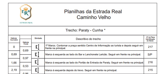
- The first column shows how far you have walked from the first milestone to your current position;
- The second column refers to the distance between the current milestone and the next milestone.
- The description contains instructions on what to do and where to go;
- In the last column you'll find the milestone numbers, but pay attention, they're on the metal plate, right at the end, almost next to the screw that holds the plate on.
Following the routes is very easy, once you get the hang of it, it flows like a charm and becomes a very enjoyable game. The only difficulty is finding some landmarks, which are sometimes the color of the landscape or are hidden by the forest or simply don't exist. Ah, when you enter the towns, between one stretch of trail and another, the route also becomes a little complicated, as there is no connection between the last landmark on the previous map and the next. the first landmark on the following spreadsheet, you need to be guided inside the town by the local information. The landmarks only take you to the towns and usually leave from the main churches. Destination chosen, lots of adventure spirit, spreadsheets understood and tent in the car! Since we didn't know where we were going to sleep, we had to be careful. Now all that's left to do is get on the road and see what awaits us, shall we? 



3 Responses
You're rocking it, woman!!!! I'm your fan!!!! :*
Mimi!
Thank you so much =) the next post has a video and more tips!
Kisses
[...] Presentation of the Royal Road, how to unravel the spreadsheets. [...]